
Hike or Ski the Mint Bomber Loop, Palmer
What: Among 100+ activities on this website, the Mint Bomber loop has to be the most stunning, most epic, most adventurous activity I have done. This hike explores some of the most beautiful parts of the Talkeetnas just northeast of Anchorage. The “mint bomber” loop traverses the reed lakes trail, climbs over bomber pass onto bomber glacier, comes up pennyroyal glacier and backdoor gap, and down the gold mint trail for a loop. At 21+ miles and 6000 ft of elevation gain, this hike is rated as Hard.
When to go: There is typically a short season to do this hike in the summer where enough snow has melted to avoid postholing long sections of the hike. This window typically falls between the end of July to mid September. The total hike can be done in a day, but most people will take 2 to 3 nights to complete it.
How to get there: https://goo.gl/maps/AJcBYHrMEbDKurGb9
Alltrails link: https://www.alltrails.com/trail/us/alaska/gold-mint-trail-and-reed-lakes-loop
Tips:
- This hike is not for the faint of heart and is considered difficult+. You can do the loop in either direction – start at the reed lakes trailhead and end at gold mint trailhead, or the other way around. Personally, I liked the reed to gold mint direction since it allowed us to break up the hike in nice manageable chunks. While described as a “loop” the two trailheads are actually a few miles apart and may require some shuttling or hitchhiking if you prefer not to walk the section connecting the two trails.
- Assuming going from reed to mint, here is a general description of the hike. You will start at the reed lakes parking lot which can be a bit rocky to get to via car. From there you start with a nice flat section for the first few miles. Soon, you’ll start a fairly steep climb as you rack up elevation towards the reed lakes. As you climb, you will quickly get into some bouldery sections requiring bolder hopping and minor route finding. Once you make it into the upper valley, you will keep climbing until you first make it to lower reed lakes. Keep going to the left of lower reed lakes and you will see a beautiful waterfall with a cathedral of the talkeetna mountains surrounding it. Once above the waterfall, you will find a gradual climb to the upper reed lakes. We decided to set up camp here for the first night.
- The next section is where things get quite difficult. You will need to ascend up bomber pass which is near vertical climb up loose scree and rock. There is no marked trail on this section, but you can look out for rock cairns along the way. It was very helpful to have a downloaded alltrails map to ensure we were aiming for the correct gap in the mountains. Be extremely careful since even large rocks can be loose. Once you make it to bomber pass, you will enjoy insane views of the upper reed lakes on side, and the bomber glacier on the other. Start to descend to bomber glacier using some of the ropes tied into the mountain. You will typically hit snow at the top of bomber glacier and may have to post hole a bit until you get to the flatter part of bomber glacier. From here, head straight across the glacier towards the mountain range in front of you to explore a crashed bomber from the 1950’s. The bomber is in immaculate shape thanks to the ice and is well worth checking out. Once you’ve seen the bomber, start to head down the glacier towards bomber hut.
- At this point, you have two options – you can climb down to bomber hut and then back up the pennyroyal valley, or you can try to cut across and save some of the elevation loss and gain. We did the cut across option but regretted it since we got into some massive boulder fields that were extremely slow going. You can choose to set up camp near bomber hut, or come up the penny royal valley a bit and camp next to one of the alpine lakes.
- From here you will have to descend up the valley towards penny royal glacier. It’s not immediately obvious which valley you will climb, so it’s handy to have a map to follow. The climb up the penny royal glacier valley can be quite steep, and it’s well worth having microspikes / crampons for the climb up the glacier itself. Once you get to the top of the glacier, you will find some ropes to climb up onto backdoor pass. Once again, you will enjoy some of the most insane views ever of the pennyroyal valley on one side and the gold mint valley on the other.
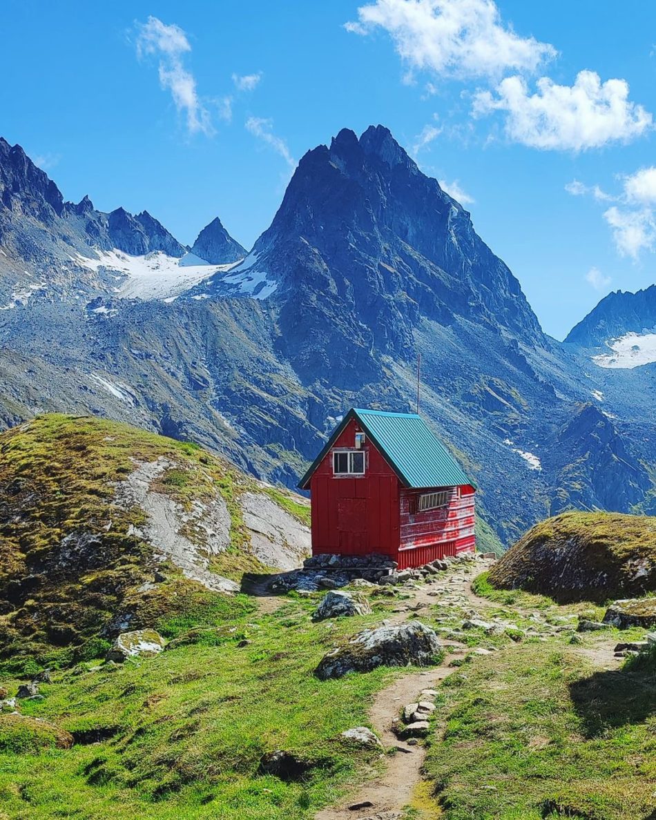
- From here, you will have a very steep descent down backdoor gap with more loose rock and scree. Keep going slowly until you eventually make it to the mint hut. The hut is a great place to stay the night, or take a break before continuing on further.
- After mint hut, you will descend further into the valley below. Once in the valley, you will have a long ~10 mile hike back to the parking lot. The first few miles of this section can be very slow going since you’ll be crossing swampy and overgrown sections. However, the final 5 or so miles are clear wide trail and will be easy to complete.
- Most people do this as backpacking trip, but it could theoretically be done as a day hike if you’re an extremely fast hiker. It’s well worth taking your time and keeping extra food in case you decide to extend the length of the trip along the way. Carry an inreach device to make sure you can be rescued if an emergency comes up.
- There are many variants of this hike – one of the most popular ones is to extend the loop by adding snowbird hut / glacier to the route. If you decide to add this, you can still start at reed lakes trailhead, but then head towards snowbird glacier. If you can keep a good pace, you could stay at snowbird hut the first night, bomber hut the second night, and mint hut the final night (or the other way around). These huts are first come first served and often have limited room. Snowbird hut can likely fit 8+ people, while bomber & mint hut can manage 4+ people.
- While many backpack this in the summer, the route and huts were actually designed for winter travel on skis. Winter travel will help avoid some of the slow going boulder fields, but certainly comes with additional complications such as avalanche danger, colder temperatures, and less daylight.
- It’s worth checking out additional blogs of the hike and downloading a hyper detailed map of the route on winterbear. You can even download this map to your phone as a layer on gaia gps – this will help avoid getting lost particularly during the sections where a trail is not evident.
Comments